ProjectB4
From !khure
Project B4: Anatomy of an old giant impact crater using magnetic imaging (from the city of Paris to the town of Parys)
French pi: A. Galdeano (with S. Gilder)
South African pi: R. Hart
Contents |
Project Participants
- South Africa: Rodger Hart, Susan Webb
- France: Armand Galdeano, Maxime Legoff
- Other: Stuart Gilder (Munich), Laurent Carpozen
Aims and objectives
- To apply magnetic imaging to map out the structure of the Vredefort impact crater in high resolution.
- To heighten the profile of the Vredefort impact crater in the light of its world heritage status, by producing useful images of important faults and subtle structural features that have an important bearing on land use (e.g. bridges, water resources).
- To apply our knowledge of the effects of meteorite impacts, to further our understanding on the relative strength of the magnetic field of Earth and other planets in our solar system.
- To provide MSc training for at least one black South African student. A student for this project has already been identified.
Introduction.
The Vredefort dome is the largest impact crater on Earth, and any new information on Vredefort sets a precedent for understanding meteorite impacts both on Earth and on the other planets in our solar system. However, our understanding of the Vredefort structure is still far from complete, and in particular we have very little knowledge of the structure of the crater core, largely because the central area is covered by younger rocks. The central core is key, as it preserves a history of crustal strength, impact, flexure and relaxation from the time when the impact formed. By combining gravity, magnetics, seismics (both Vibroseis and teleseismic), and MT data we can build up an unprecedented 3D model of the structure at depth.
Aeromagnetic Surveys
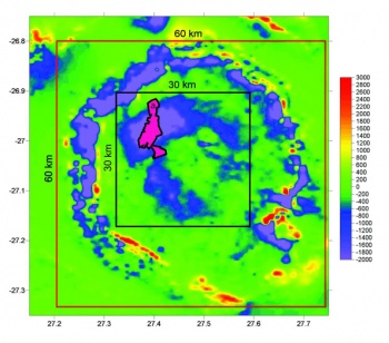
Low resolution aeromagnetic images with 1km line spacing over the structure show strong, well-defined concentric patterns (Fig. 1). In the rim, the patterns reflect the different sedimentary strata of the Witwatersrand basin. A prominent negative magnetic anomaly that extends in a broad semicircular belt ~2 to 4 km wide around most of the basement core (inner 30x 30km insert; Fig.1.) is roughly centered above the amphibolite-granulite facies transition which is recognized as a fundamental boundary within the crust and is commonly considered to designate the transition from middle to lower crustal levels [1]. The Vredefort crater contains the only exposure of the amphibolite-granulite facies transition in Southern Africa.
Proposed Research Program
High resolution ground magnetic survey
In order to establish the relationship of the negative anomaly to the amphibolite-granulite facies transition zone we undertook a high-resolution ground magnetic surveys over a well-exposed section of the amphibolite-granulite transition (insert a Fig. 2.) The results of this study shows that the magnetic signatures across this transition correlate closely with the geology [2]. In particular, with the transition zone and the the impact related faults that transect the basement. Thus, the results of our pilot study show that detailed ground magnetic surveys can precisely delineate lithological boundaries as well as the impact related radial and concentric faults that juxtapose the different geological units.
In our proposed project we plan to extend our high resolution survey over the entire central part of the crater (inner 30x 30km insert; Fig.1) in order to map out the detailed geological structures of the crater core. We intend to do a ground magnetic survey using a Geometrics cesium vapour magnetometer (G-858) and a newly developed vectorial magnetometer. Geographic positions will be collected simultaneously using a GPS receiver. Data will be recorded at 1-second intervals which will yield spatial separation between 1 to 1.5 m.. The GPS positioning has an accuracy of about 10 meters. The average spacing of survey lines will be ~25 m (Fig. 4a).
Mode of co-operation between the French and South African research teams.
The project will involve bilateral travel between France and South Africa for both research teams, including post-graduate students, for fieldwork, acquisition of analytical data (including training of French and South African students), and interpretation, presentation and publication of results. Both teams will serve as supervisors of the post-graduate students. 2 seasons of fieldwork (duration of about one month each season) are planed for 2007 and 2008.
Capitalizing on other geophysical studies
- Magnetotelluric data have recently been collected in the region that have the potential to image to upper mantle depths.
- Deep (16 sec) seismic data of the region collected during the Kaapvaal seismic program is also available.
References
- Hart, R. J., Andreoli, M. A. G., Reimold, W. U. and Tredoux, M. (1991). Aspects of the dynamic and thermal metamorphic history of the Vredefort structure: implications for its origin: Tectonophysics, v. 192, p. 313-331.
- Manfriedt Muundjua, Rodger J. Hart, Stuart A. Gilder, Laurent Carporzen , Armand Galdeano, (2007) Magnetic Imaging of the Vredefort Impact crater, South Africa Earth and Planetary Science Letters (in Press)


