ProjectA3
From !khure
Project A3:
Plateau uplift, epeirogeny and evolution of climate and biodiversity
French pi: F. Guillocheau
South African pi: M. de Wit
Project Participants:
South Africa
- Fernando Abdala, University Witwatersrand - I - Therapsid taxonomy
- Marion Bamford, University Witwatersrand - I - Fossil wood taxonomy
- Jennifer Botha-Brink, National Museum - I - Parareptiles, Bone histology, physiology
- Doug Cole, Council for Geoscience - I - Sedimentology, lithostratigraphy
- John Compton, University of Cape Town - V - Marine Sedimentology
- Woody Cotterill, University of Cape Town - I,III - Biodiversity dynamics, palaeo drainage
- Maarten de Wit, University of Cape Town - I,II, III - Tectonics, geochronology,
- Frank Eckardt, University of Cape Town - III - Geomorphology, palaeo-drainage
- Julia Lee-Thorpe, University of Bedford - III - Biology, stable isotopes, hominims
- Johann Neveling, Council for Geoscience - I - Sedimentology, basin modelling
- Merrill Nicolas, University Witwatersrand - I - GIS database
- Rose Prevec, Albany Museum - I - Megaplant taxonomy
- Bruce Rubidge, University Witwatersrand - I - Therapsid taxonomy, biostratigraphy
- Roger Smith, SA Museum - I - Taphonomy, biodiversity changes
- Adam Yates, University Witwatersrand - I - Dinosaur taxonomy
France
- Sylvie Bourquin, Rennes 1 University - I - Fluvial sedimentology
- Jean Braun, Rennes 1 University - II - Modelling
- Luc Bulot, Marseille University - II - Biostratigraphy
- Olivier Dauteuil, Rennes 1 University - II - Tectonics
- Francois Guillocheau, Rennes 1 University - I, II, III - Sedimentology, Seismic stratigraphy
- Alain Le Herisse, Brest University - I - Palynology
- Cécile Robin, Rennes 1 University - I, II - Sedimentology, Seismic stratigraphy
- Delphine Rouby, Rennes 1 University - II - Seismic stratigraphy
- Martine Simoes, IPGP - II - Modelling
- Paul Tapponier, IPGP - II - Tectonics
- Jean-Jacques Tiercelin, Rennes 1 University - III - Sedimentology
- Annie Vincens, CEREGE, Marseille - III - Palynology
Background

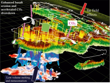
The Kalahari Plateau is a 1000-1500 m high plateau that stretches ~2500 km from southern to central Africa. It is the world‟s largest subcontinental plateau away from plate margins, and is separated from the Atlantic and Indian Oceans by a narrow transition of steep scarps and mountain ranges. The origin of this plateau and its margins are not understood but can be traced back to peneplanation near sea-level during the continent-wide end-Paleozoic Gondwana glaciation (~300 My), followed by extensional intracontinental tectonics and desertification during the Late Permian-Triassic (Karoo rifts and basins) and continental break-up during the the Late Jurassic - Early Cretaceous (formation of the Atlantic and Indian Oceans). The peneplain was also affected by extensive volcanic activity: three large flood basalt events (the Karroo, 170-180 My; the Etendeka, 132 My; and the Aghulas (100-90 My) and two punctuated episodes of kimberlite emplacement (around 120 My and 90 My). By mid-end Cretaceous, uplift had started and concomittantly the inland region was transformed into a continental desert. Cenzoic evolution of the Kalahari Plateau has strongly controlled geomorphology, biological evolution (including Hominids), climate change and the hydrology of central and southern African.
The goal of this project is to quantify the growth of this major topographic feature of the Earth – the very long wave length Plateau topography, and the associated rates of uplift over the last 300 My, in order to understand the dynamics of Africa‟s surface processes (erosion, transport, sedimentation) climate change, hydrology, and biological evolution in response to landscape evolution.
The growth of the Kalahari Plateau is contemporaneous also with a major climatic change at global scale, as well as changes in both elevation and tenures of large lakes and wetlands (including aquifers) across the Plateau. The question of the climate change over the past few tens of millions years in Africa is of primary importance to predict the climate of the future and to understand the evolution of the Hominids in Africa.
Questions:
- What was the initial topography, prior to the growth of the Plateau?
- Was the Plateau growth continuous or discontinuous, and at what rate?
- Did the observed uplift drive local/global climate change?
- How did Plateau uplift affect lake and river drainage and biodiverity evolution?
- Is the Plateau currently rising (or subsiding) and deforming?
- How is the East African Rift migrating southwards and merging/dissecting the Kalahari Plateau?
- A3.I: Carboniferous to Early Jurassic paleotopography and paleoclimate of South Africa: The Karroo Group
- A3.II: The kinematics of Kalahari Plateau uplift through meso-cenozoic times: a sequence stratigraphic approach
- A3.III: The Kalahari “Basin” infilling: age, paleotopography and paleoclimate
Capacity Building through Interactive student mentoring and development
Exchange between South African and French students.
- 1 South African PhD and 2 French MSc students on the Upper Karroo sedimentology and sequence stratigraphy (Wits/Rennes)
- 1 South African PhD student on the seismic stratigraphy of the Margin (UCT/Rennes)
- 1 French or South African PhD and 2 South African MSc students on the core analysis of drillings (sedimentology and sequence stratigraphy) of the Kalahari deposits (UCT/Rennes)
- 2 South African MSc on palaeoegeomorphology (South African Escarpment evolution)
- 1 South African Post-Doc for compilation and synthesis of palaeo-environmental scenarios in geospatial context, building on AEON databases (UCT/Rennes/IPGP
Economic implications and industry collaborations
We can expect economic implications of our studies on uranium geology (subproject I), on petroleum and gas location and migration (subproject II) and on sedimentary diamonds prospects (subprojects II and III). The following companies have shown interests in participation: South African Petroleum, De Beers, BRC diamond)
Relevent review reference:
- de Wit, M.J. 2007. The Kalahari epeirogeny and climate change: differentiating cause and effect from core to space. South African Journal of Geology, 110, 367-392


