ProjectA2
From !khure
Project A2:
Evolution of African rift propagation into Southern Africa
French pi: P. Tapponnier
South African pi: F. Cotterill
Project Participants
- Paul Tapponnier Tectonics, IPGP
- Woody Cotterill University of Cape Town, AEON, and Department of Geological Sciences & Department of Molecular and Cell Biology, South Africa.
- Geoffrey King Tectonics, IPGP
- Laurie Barrier Tectonics, IPGP
Project
One of the key issues with high plateaus is to understand how their flat and high topography is preserved from the attacks of headward erosion. Whatever the origin of the Kalahari plateau, and whether it is presently rising, subsiding, or stable, it seems to have been at an elevation of 1500 m or so for a significant period of time (Mid Cenozoic, Cretaceous or earlier). How could it maintain its flatness at such elevation for such a long time? A significant fraction of the plateau remains internally drained today, and there is evidence that the internally drained surface used to be much larger, with the presence of one or several large lakes.
Because mechanisms that preserve local high base levels commonly involve recent and active faulting, we propose to study the relationship between such faulting and the evolution of topography and endorheism. Although South Africa and the Kalahari are not very seismic regions, there is evidence of recent and active tectonics in several areas.
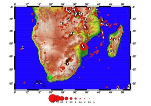
1/ In the Northwest, one branch of the East African rift (EAR) splays off southwestwards towards the Okavango delta, in the very heart of the Kalahari plateau. More should be known about the corresponding normal faults. At what rate do they move? How did they propagate? Do they still do so today? Did they control the sequential capture of Kalahari rivers by the lower Zambezi (Victoria falls?).
2/ In the Northeast and East, one main branch of the EAR has extended into the Mozambique basin. There is also current uplift along the coast south of Durban. Again, little is known about the potential southward propagation or reactivation of recent normal faults along the east side of the plateau. Both questions are related to the mechanics of the southward termination of the EA Rift, a problem that has received less attention than its counterpart to the north.
3/ In the south, at least two fairly large earthquakes (M ≥ 6) have shaken the west part of the Cape Foldbelt (e.g., 1969 Ceres earthquake), but the present day regime of deformation is poorly understood. In general, the foldbelt shows up to ≈ 2 km of local relief, which is more than observed in belts of roughly comparable age (e.g. Urals, Appalachian). It seems unlikely that differential erosion of quartzites or tectonic inversion and normal faulting in the Cretaceous suffice to account for such relief. In fact, some of the roughly EW-striking Cretaceous normal faults appear to be active (e.g., Kango fault). How is such deformation connected with regional plate tectonics?
By using the combination of quantitative geomorphology, surface exposure dating, accurate mapping using DEM and high resolution satellite images that we have successfully applied to other neotectonic problems, we propose to understand and model the recent deformation of South Africa and its bearing on plateau and drainage system evolution. This short-term vision of deformation (1 to x10 million years) will be linked and integrated with the longer time scale documented by sedimentology and other approaches.


